KML has really taken off as a format for posting geospatial data on the Web. Bringing that data into a GIS offers a lot of analytic options for a great price.
Thursday, July 28, 2011
Converting KML to Shapefiles
An update to the free and open source KML2Shapefile extension for MapWindow GIS has been posted. There are a number of fixes to and enhancements to make conversion faster and easier.


Thursday, May 05, 2011
Shape2Earth 2.0
Shape2Earth for MapWindow GIS provides simple tools for converting shapefiles to Keyhole Markup Language (KML) for viewing GIS data in Google Earth. It runs as a plugin to the free and open source MapWindow GIS, which is an excellent .NET based GIS desktop application. The purpose of releasing Shape2Earth as a plugin to MapWindow was to take advantage of all of the shapefile tools that MapWindow makes available.
One drawback to this approach was that using MapWindow required a little bit of knowledge on general GIS workflows. Users needed to download MapWindow, then download Shape2Earth into a specific directory so that MapWindow could see it as a plugin, activate Shape2Earth in MapWindow, load a shapefile, and then know how to adjust the symbology of the shapefile using MapWindow, and then export the shapefile to KML using MapWindow.
Shape2Earth 2.0 works on top of the new Shape2EarthEngine, and greatly simplifies the process. Users can run Shape2Earth 2.0 without having to launch any additional programs. Shape2EarthEngine provides its own shapefile reader and symbol rendering engine. It does not require the use of MapWindow GIS, or any of its components.
While Shape2EarthEngine has been decoupled from MapWindow GIS, it can still run as a plugin to MapWindow, just like the original Shape2Earth. This lets users take advantage of all that MapWindow has to offer in terms of managing shapefiles and cartographically defining the symbology for export as a KML file.
Besides being able to run stand-alone, or with MapWindow, Shape2Earth 2.0 offers many new and improved options for letting people create compelling Google Earth maps using shapefiles.
Shape2Earth 2.0 and Shape2EarthEngine are still under development. I hope to have it available for beta testing by current Shape2Earth customers in the coming months.
One drawback to this approach was that using MapWindow required a little bit of knowledge on general GIS workflows. Users needed to download MapWindow, then download Shape2Earth into a specific directory so that MapWindow could see it as a plugin, activate Shape2Earth in MapWindow, load a shapefile, and then know how to adjust the symbology of the shapefile using MapWindow, and then export the shapefile to KML using MapWindow.
Shape2Earth 2.0 works on top of the new Shape2EarthEngine, and greatly simplifies the process. Users can run Shape2Earth 2.0 without having to launch any additional programs. Shape2EarthEngine provides its own shapefile reader and symbol rendering engine. It does not require the use of MapWindow GIS, or any of its components.
While Shape2EarthEngine has been decoupled from MapWindow GIS, it can still run as a plugin to MapWindow, just like the original Shape2Earth. This lets users take advantage of all that MapWindow has to offer in terms of managing shapefiles and cartographically defining the symbology for export as a KML file.
Besides being able to run stand-alone, or with MapWindow, Shape2Earth 2.0 offers many new and improved options for letting people create compelling Google Earth maps using shapefiles.
Shape2Earth 2.0 and Shape2EarthEngine are still under development. I hope to have it available for beta testing by current Shape2Earth customers in the coming months.
Monday, January 17, 2011
Google Earth Portable Server
Google is now offering a Google Earth Portable Server as part of their enterprise offerings. This architecture lets users select their area of interest from a web page with the Google Earth Plugin embedded in it. This are is extracted and downloaded on to their computer, and is served to the Google Earth Enterprise client, or to a web page with the Google Earth Plugin.
This configuration offers a lot of flexibility for use, and can run completely disconnected from the network. This is a big deal for government and DoD customers.
Similar solutions in the past made use of Linux virtual machines running a Google Earth Server connected to a Windows machine. The new configuration is much more elegant and manageable.
This architecture will make a lot of sense for military use. Soldiers could select there are of interest from an NGA server, and then download their imager, vector data, and applications as a deployable bundle that can operate disconnected, or in conjunction with other services.
Friday, March 05, 2010
Kml2Shapefile for MapWindow GIS
Kml2Shapefile has been released as an open source KML/KMZ to shapefile converter. It is a plugin for the free MapWindow GIS. It needs a bit more testing. There are a lot of KML files out there.
I was going to provide the option to reproject the data, but decided the the user can do that easy enough in MapWindow after the shapefile has been created.
Kml2Shapefile will split the geometries out of KML into separate shapefiles (points, lines, polygons) and supports Z values and multipoints.
Currently, you can save the following as attributes:
- Placemark name
- Placemark snippet
- Placemark description
- Description HTML tables (needs more testing)
- Lat/Long of point data
- Elevation of point data
The ability to save custom schema's will come later. I thought it was best to get this our for testing.
Saturday, December 19, 2009
Shapefiles for Web Mapping
KML is becoming a standard way to display geospatial data on the internet. With all of the really good web mapping platforms available today, you can take your pick on how you would like to show off your GIS data to a large audience.
Shape2Earth can get your GIS data on the web quickly by converting your shapefiles to KML for display in Google Earth, Google Maps, or Bing Maps.
Here is a quick example of showing off GIS data in Google's App Engine platform with Google Earth. It's important to note that this capability is essentially free. Google will host your spatial application. All you have to do is put it together.
Shapefiles in in Google's App Engine (select the Shape2Earth layers on the right).
Wednesday, December 16, 2009
Shape2Earth Users Guide
Shape2Earth has a much needed Users Guide on line to help get people going converting shapefiles to KML. Shape2Earth is very easy to use, but there is a lot that can be done with it in conjunction with MapWindow, and this guide should help those without a GIS background.
There is still some work to be done on the Guide, but I thought that getting the current information out there was more important than having 100% of the content filled out.
Shape2Earth 2.0 is also under works. It is mostly a redesigned form that takes into account lessons learned from Shape2Earth 1.0 for MapWindow. Shape2Earth 2.0 will still work with MapWindow to take advantage of its advanced GIS capabilities, but will also be able to run independently. The core management and conversion has been moved into Shape2Earth Engine. This will make it much easier for things such as batch converting of shapefiles, and embedding Shape2Earth into other applications
Saturday, November 21, 2009
Shape2Earth for MapWindow GIS 4.7 Released
Shape2Earth for MapWindow 4.7 has been released. Shape2Earth is the quickest, easiest, and cheapest way to convert shapefiles into Keyhole Markup Language (KML) for viewing in Google Earth.
This version of Shape2Earth offers a number of improvements, including:
1. Better handling of complex geometries
2. Ability to add custom balloon styles
3. Exporting of selected data, or data in a specific area
4. Sorting of spatial features into KML Folders based on an attribute
5. Higher accuracy on geo-referenced Google Earth image captures
Shape2Earth has been downloaded over 32,000 times in the last 18 months, and has been found to be exceptionally useful and cost effective by local and federal government agencies, as well as industry leaders in a multitude of professional specialties.
Download Shape2Earth and try it on your own data today.
This version of Shape2Earth offers a number of improvements, including:
1. Better handling of complex geometries
2. Ability to add custom balloon styles
3. Exporting of selected data, or data in a specific area
4. Sorting of spatial features into KML Folders based on an attribute
5. Higher accuracy on geo-referenced Google Earth image captures
Shape2Earth has been downloaded over 32,000 times in the last 18 months, and has been found to be exceptionally useful and cost effective by local and federal government agencies, as well as industry leaders in a multitude of professional specialties.
Download Shape2Earth and try it on your own data today.
Friday, October 02, 2009
MapWindow GIS User and Developer Conference

The 1st International MapWindow GIS User and Developer Conference will be held in Orlando, FL, from 31 March to 2 April 2010.
MapWindow is a .NET, open source, easy to use, desktop GIS that can be extended through plugins.
MapWindow is a .NET, open source, easy to use, desktop GIS that can be extended through plugins.
Friday, May 29, 2009
Shape2Earth4GPS Alpha

I have been working on a Google Earth based application that uses their new Plugin in a .NET Form called Shape2Earth4GPS. It is an experiment on being able to edit spatial data (in this case, GPS data) directly on the Globe.
Currently, it works very well for digitizing your waypoints and routes, and then saving them as GPX files to upload into your favorite GPS receiver. You can also load and edit your existing waypoints, routes, and tracks.
If anyone would like to act as a beta tester for Shape2Earth4GPS, please send me a note at sabin21@gmail.com
Currently, it works very well for digitizing your waypoints and routes, and then saving them as GPX files to upload into your favorite GPS receiver. You can also load and edit your existing waypoints, routes, and tracks.
If anyone would like to act as a beta tester for Shape2Earth4GPS, please send me a note at sabin21@gmail.com
Thursday, May 28, 2009
ArcGIS Explorer - Color Coding Shapefile Data
I’ve been working on an ArcGIS Explorer stand-alone application that needs to let users select buildings inside of a buffer that is created around a user defined point. The attributes of the selected buildings and their colors need to be changed to indicate their status. The user will also be able to click on a building to select it, and then be able to change the status of the building (by changing the color/attribute of the selected building).
Using shapefiles, a file based personal geodatabase, or an ArcSDE geodatabase won’t work, because it does not look like you can have an attribute based coloring scheme. There also does not appear to by any way to extrude the shapefiles, and the building need to be 3D.
I can use KML to extrude buildings and change the color of individual features, but I cannot run any of the spatial operations on a KML file.
I am getting around this by using both shapefiles and KML. I’m using the ArcGIS Explorer API to generate KML form the shapefiles on the fly. Each KML Placemark has an ID that is equal to the shapefile FeatureID. I’m using the API to select features from the shapefile based on a point (for selecting an individual building) or by area (to select t group of buildings from a buffer). I can then open the XML/KML file, get the associated Placemarks by matching their Id to the FID, change their style to reflect the change in attribution, and then reload to view the change.
This seems to be a nice way to get around some of the limitations in ArcGIS Explorer to make it quite a bit more useful for my application requirements. This method also seems to work with file based personal geodatabases and ArcSDE.
Using shapefiles, a file based personal geodatabase, or an ArcSDE geodatabase won’t work, because it does not look like you can have an attribute based coloring scheme. There also does not appear to by any way to extrude the shapefiles, and the building need to be 3D.
I can use KML to extrude buildings and change the color of individual features, but I cannot run any of the spatial operations on a KML file.
I am getting around this by using both shapefiles and KML. I’m using the ArcGIS Explorer API to generate KML form the shapefiles on the fly. Each KML Placemark has an ID that is equal to the shapefile FeatureID. I’m using the API to select features from the shapefile based on a point (for selecting an individual building) or by area (to select t group of buildings from a buffer). I can then open the XML/KML file, get the associated Placemarks by matching their Id to the FID, change their style to reflect the change in attribution, and then reload to view the change.
This seems to be a nice way to get around some of the limitations in ArcGIS Explorer to make it quite a bit more useful for my application requirements. This method also seems to work with file based personal geodatabases and ArcSDE.
Friday, February 27, 2009
Create and Edit GPX In Google Earth
The Google Earth plugin is offering many new opportunities for writing custom web-based and desktop applications. iEarth is an experiment that uses Google Earth as the map for interacting with GPS and GIS data.
The Google Earth plugin is intended for use in a web page, but can also be embedded in a desktop application in a web control or referenced as an ActiveX control.
A common method for embedding the Google Earth plugin in a desktop application can be viewed online as a part of the Google Earth code samples.
Part of what makes the Google Earth plugin so much more flexible than its desktop counterpart is the programmatic control that is given to developers through its API.
Not only can spatial data be loaded as KML, but the source data can be directly manipulated through the Google Earth interface.
An example of this is the GPX editor seen below.
GPX is an XML based exchange format for GPS data such as waypoints, routes, and tracks. The GPX editor in iEarth can load existing GPX data for viewing or editing, and also lets users digitize and edit data from scratch. The data is translated into KML for viewing in Google Earth, but is kept in internally in the GPX format for saving.
This same method can be used with Shapefiles. The next release of Shape2Earth will embed a link to the shapefile so that editing spatial or attribute data in iEarth will also edit the shapefile.
 Google Earth Plugin in iEarth
 Digitize a GPX Waypoint and enter data

View the GPX attributes in the Google Earth Balloon

Digitize Routes in Google Earth and save as GPX for use in GPS Receivers

Right click on existing data to edit the attribute data

The Google Earth plugin is intended for use in a web page, but can also be embedded in a desktop application in a web control or referenced as an ActiveX control.
A common method for embedding the Google Earth plugin in a desktop application can be viewed online as a part of the Google Earth code samples.
Part of what makes the Google Earth plugin so much more flexible than its desktop counterpart is the programmatic control that is given to developers through its API.
Not only can spatial data be loaded as KML, but the source data can be directly manipulated through the Google Earth interface.
An example of this is the GPX editor seen below.
GPX is an XML based exchange format for GPS data such as waypoints, routes, and tracks. The GPX editor in iEarth can load existing GPX data for viewing or editing, and also lets users digitize and edit data from scratch. The data is translated into KML for viewing in Google Earth, but is kept in internally in the GPX format for saving.
This same method can be used with Shapefiles. The next release of Shape2Earth will embed a link to the shapefile so that editing spatial or attribute data in iEarth will also edit the shapefile.
 Google Earth Plugin in iEarth
 Digitize a GPX Waypoint and enter data
View the GPX attributes in the Google Earth Balloon

Digitize Routes in Google Earth and save as GPX for use in GPS Receivers

Right click on existing data to edit the attribute data

Wednesday, July 30, 2008
ESRI Online Services + Microsoft Virtual Earth
An announcement from ESRI and Microsoft.
Users of ESRI’s ArcGIS will now be able to directly load base map data from the Microsoft Virtual Earth platform into the ArcGIS 9.3 Desktop and Explorer. Data layers will include the high resolution street maps, imagery, and hybrid that we have become accustom to seeing in Microsoft’s Virtual Earth.
Access to this data requires a subscription to ArcGIS Online Service.
Imagery can be previewed at http://resources.esri.com/arcgisonlineservices.
Users of ESRI’s ArcGIS will now be able to directly load base map data from the Microsoft Virtual Earth platform into the ArcGIS 9.3 Desktop and Explorer. Data layers will include the high resolution street maps, imagery, and hybrid that we have become accustom to seeing in Microsoft’s Virtual Earth.
Access to this data requires a subscription to ArcGIS Online Service.
Imagery can be previewed at http://resources.esri.com/arcgisonlineservices.
Virtual Earth ASP.NET Control
Using the Virtual Earth map in your web page is nothing new. What is new about this control is that you can drop it into your ASP.NET project in Visual Studio and get it running without the need for any client side JavaScript. All of the parameters can be set in Visual Studio and all of the code to manipulate and interact with the map and map data and can be written in server side .net code.
The Windows Live Dev Blog points out that the map can be made even more interactive through the use of ASP.NET AJAX.
This control is one of several that Microsoft is offering as part of their Live Tools for Microsoft Visual Studio.
The Windows Live Dev Blog points out that the map can be made even more interactive through the use of ASP.NET AJAX.
This control is one of several that Microsoft is offering as part of their Live Tools for Microsoft Visual Studio.
Wednesday, July 09, 2008
Shapefile to GeoRSS for Google Maps
The most recent version of Shape2Earth includes a functional prototype for converting shapefiles to a GeoRSS format. It currently works with simple lines and points. Attribute data can be selected to be embedded in the GeoRSS feed.
 Select the attributes you wish to export to GeoRSS
 Attributes can be embedded in the xml, listed as a table, or both
GeoRSS is a very popular format, and is particularly useful for serving data to web mapping applications such as Google Maps.
Attributes can be embedded in the xml, listed as a table, or both
GeoRSS is a very popular format, and is particularly useful for serving data to web mapping applications such as Google Maps.
View the Google Map/GeoRSS sample to see how point GIS data can be viewed.
 Select the attributes you wish to export to GeoRSS
  Attributes can be embedded in the xml, listed as a table, or both
View the Google Map/GeoRSS sample to see how point GIS data can be viewed.
Tuesday, June 24, 2008
Google Earth Custom Icon Editor
The Shape2Earth icon editor for creating KML files has been greatly enhanced recently. Users now have an interface that is very similar to the one they use in Google Earth, and the ability to add their own custom icons to point data.
 New icon selection window pulls icons from the Google Earth folder
 New icon selection window pulls icons from the Google Earth folder
 Custom icons can be added to the pallete
 Custom icons will stay in the icon window for later use
 Shape2Earth icons can be changed when the user 'hovers' over an icon in Google Earth
Friday, April 18, 2008
Leica TITAN
Leica Titan has actually been out for a while. There is a post on OgleEarth from December 2006 when the first product was just coming out. My first try with it was not so smooth. But recent updates have gone much better.
It appears to be your standard 3d earth browser, but is oriented more towards data sharing and collaboration. It has a built in instant messanger to share your spatial data with others.
It appears to be your standard 3d earth browser, but is oriented more towards data sharing and collaboration. It has a built in instant messanger to share your spatial data with others.

Leica Titan Globe

Search for a Place and zoom

Load a shapefile. It seems to be able to handle many different formats.

You can change feature colors (not based on attributes).
 Click on a loaded feature to view attributes
You can also load photos and place notes on the Earth to send to others. Performance was not to bad, though navigation was a bit touchy and took some getting used to. It seemed to me to be a bit like ArcGIS Explorer, but without the extensibility.
Leica TITAN is available for download.
Thursday, April 17, 2008
Google Earth Version 4.3 Released
Google Earth 4.3 was released on Wednesday, April 15. The biggest changes for most people (not power users of course) is a revamped navigation control and much different lighting on the planet.
The new lighting makes the Earth look much brighter, and the orientation of the light can be changed by moving the position of the Sun based on the time of day. This does not really make Google Earth better, it just makes it look different than in the past.
The new navigation control takes some getting used to, but it does let users move in ways that were not really possible before. There is more of a hover mode that makes is easier to move around when you are zoomed in close to an object, such as a model. This is a much bigger deal to me. Google Earth has always been good for navigating on a global scale, but needs some better controls for moving around a regional or smaller scale.
I had some problems with Google Earth locking up on me. I am staying with 4.2 until the next release, which typically cleans up a lot of issues.
Much better write ups on new functionality and a video can be seen at Google Earth Blog, and at Google LatLon , with some nice general thoughts at OgleEarth.
The new lighting makes the Earth look much brighter, and the orientation of the light can be changed by moving the position of the Sun based on the time of day. This does not really make Google Earth better, it just makes it look different than in the past.
The new navigation control takes some getting used to, but it does let users move in ways that were not really possible before. There is more of a hover mode that makes is easier to move around when you are zoomed in close to an object, such as a model. This is a much bigger deal to me. Google Earth has always been good for navigating on a global scale, but needs some better controls for moving around a regional or smaller scale.
I had some problems with Google Earth locking up on me. I am staying with 4.2 until the next release, which typically cleans up a lot of issues.
Much better write ups on new functionality and a video can be seen at Google Earth Blog, and at Google LatLon , with some nice general thoughts at OgleEarth.
Monday, March 24, 2008
Open Source Geospatial Metadata Editor
One of the most important and often overlooked aspects of geospatial data is the associated metadata. In a nutshell, metadata is “data about data”. It provides the background information on the what, when, where, and how of a spatial dataset.
As an example, if you are going to be making decisions based on a spatial dataset, you need to know how accurate and/or precise the data is. Data may have been collected using high grade survey equipment, or it may have been digitized from the educated guess of a subject matter export. Both of these data may be useful, as long as the user knows about these accuracy issues.
ESRI provides two different metadata editors in ArcCatalog. One uses the FGDC metadata profile, and the other an ISO profile (both have some extra ESRI elements added).
The new release of MapWindow GIS (a freely available, open source GIS) has an excellent metadata extension that provides a number of metadata creation, management, and visualization tools.
The Editor can be launched from MapWindow, and can show metadata from a loaded shapefile, or from a metadata xml file loaded from the user interface. Metadata can also be viewed using a number of built in styles sheets.
The metadata editor seems to work very nicely. One change I would like to see would be the ability to store user contact information so that newly created metadata could be updated more easily.
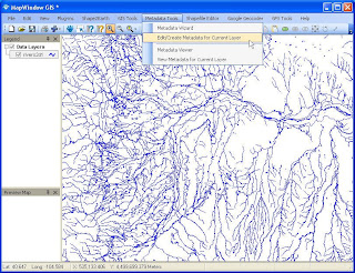 The Metadata Editor can be launched from MapWindow
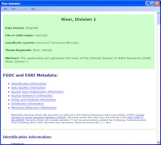 Metadata can be quickly viewed using a number of built in style-sheets.
As an example, if you are going to be making decisions based on a spatial dataset, you need to know how accurate and/or precise the data is. Data may have been collected using high grade survey equipment, or it may have been digitized from the educated guess of a subject matter export. Both of these data may be useful, as long as the user knows about these accuracy issues.
ESRI provides two different metadata editors in ArcCatalog. One uses the FGDC metadata profile, and the other an ISO profile (both have some extra ESRI elements added).
The new release of MapWindow GIS (a freely available, open source GIS) has an excellent metadata extension that provides a number of metadata creation, management, and visualization tools.
The Editor can be launched from MapWindow, and can show metadata from a loaded shapefile, or from a metadata xml file loaded from the user interface. Metadata can also be viewed using a number of built in styles sheets.
The metadata editor seems to work very nicely. One change I would like to see would be the ability to store user contact information so that newly created metadata could be updated more easily.
 The Metadata Editor can be launched from MapWindow
 A simple to use TreeView lets users navigate through metadata elements

I would like to see a change so that users can save contact profiles for quick loading.
Of course this is open source, so there is nothing stopping me!
 Metadata can be quickly viewed using a number of built in style-sheets.
MapWindow GIS 4.5 Release Candidate 2
The MapWindow Team released a second candidate for MapWindow GIS 4.5. The second candidate release was due to all of the new enhancements that are packaged with this version of MapWindow.
MapWindow is a Microsoft .NET based, extensible, open source, geographic information system (GIS) for the desktop. It has an active user community, and has been releasing new versions at a regular pace. It's plugin model allows developers to quickly create powerful, custom tools that can be streamlined for specific business purposes at a fraction of the cost when compared to more robust systems.
MapWindow is an excellent GIS package for those who want some basic GIS functionality. I find myself using MapWindow much more often than ArcMap for my day-to-day GIS work. It's just much quicker to start up and getting going with for my run of the mill GIS work.
The most recent 4.5 candidate offers a number of new plugins that are making MapWindow even better. Among them are:
These are in addition to a number of other plugin extensions that have already been made available.
And, of course, there is the Shape2Earth shareware plugin that converts GIS data to KML for viewing in Google Earth and Google Maps.
MapWindow is a Microsoft .NET based, extensible, open source, geographic information system (GIS) for the desktop. It has an active user community, and has been releasing new versions at a regular pace. It's plugin model allows developers to quickly create powerful, custom tools that can be streamlined for specific business purposes at a fraction of the cost when compared to more robust systems.
MapWindow is an excellent GIS package for those who want some basic GIS functionality. I find myself using MapWindow much more often than ArcMap for my day-to-day GIS work. It's just much quicker to start up and getting going with for my run of the mill GIS work.
The most recent 4.5 candidate offers a number of new plugins that are making MapWindow even better. Among them are:
- A Great Metadata creation, viewing, and editing tool.
- A GPS connection and tracking plugin.
- A connection to PostGIS data
- Google Geocoder Tool.
- Enhancements to the Shapefile Editor
These are in addition to a number of other plugin extensions that have already been made available.
And, of course, there is the Shape2Earth shareware plugin that converts GIS data to KML for viewing in Google Earth and Google Maps.
Monday, February 04, 2008
KML for Web Mapping
Keyhole Markup Language (KML) is starting to become a de facto standard for transmitting spatial data. Both Google Maps and Microsoft's Virtual Earth have added support for viewing KML data. In both of these cases, it is necessary to make the KML file available on the web so that Google and/or Microsoft can access the file and process it to be viewed in their map controls.
Google Map's, as you might imagine, is getting much better at displaying KML on their web map. The example below shows a KML file (created by Shape2Earth) showing the total number of households by state.
First in Google Map:
http://maps.google.com/maps?q=http://shape2earth.com/Documents/states_NumHouseholds.kml
Then in Virtual Earth.
http://maps.live.com/?mapurl=http://shape2earth.com/Documents/states_NumHouseholds.kml
Note how the geometries in Virtual Earth do not line up very well, and in some cases, are not visible at all. Virtual Earth also seems to automatically add a center point, and does not adhere to the KML coloring scheme. If you switch to 3D mode, the geometries will line up much better, but the fill color seems to be absent.
It looks like any investments that you might be making in KML converters are going to be beneficial for some time to come.
Google Map's, as you might imagine, is getting much better at displaying KML on their web map. The example below shows a KML file (created by Shape2Earth) showing the total number of households by state.
First in Google Map:
http://maps.google.com/maps?q=http://shape2earth.com/Documents/states_NumHouseholds.kml
Then in Virtual Earth.
http://maps.live.com/?mapurl=http://shape2earth.com/Documents/states_NumHouseholds.kml
Note how the geometries in Virtual Earth do not line up very well, and in some cases, are not visible at all. Virtual Earth also seems to automatically add a center point, and does not adhere to the KML coloring scheme. If you switch to 3D mode, the geometries will line up much better, but the fill color seems to be absent.
It looks like any investments that you might be making in KML converters are going to be beneficial for some time to come.
Subscribe to:
Posts (Atom)