Showing posts with label GPS. Show all posts

Friday, February 27, 2009

Create and Edit GPX In Google Earth

The Google Earth plugin is offering many new opportunities for writing custom web-based and desktop applications. iEarth is an experiment that uses Google Earth as the map for interacting with GPS and GIS data.

The Google Earth plugin is intended for use in a web page, but can also be embedded in a desktop application in a web control or referenced as an ActiveX control.

A common method for embedding the Google Earth plugin in a desktop application can be viewed online as a part of the Google Earth code samples.

Part of what makes the Google Earth plugin so much more flexible than its desktop counterpart is the programmatic control that is given to developers through its API.

Not only can spatial data be loaded as KML, but the source data can be directly manipulated through the Google Earth interface.

An example of this is the GPX editor seen below.

GPX is an XML based exchange format for GPS data such as waypoints, routes, and tracks. The GPX editor in iEarth can load existing GPX data for viewing or editing, and also lets users digitize and edit data from scratch. The data is translated into KML for viewing in Google Earth, but is kept in internally in the GPX format for saving.

This same method can be used with Shapefiles. The next release of Shape2Earth will embed a link to the shapefile so that editing spatial or attribute data in iEarth will also edit the shapefile.


Google Earth Plugin in iEarth


Digitize a GPX Waypoint and enter data


View the GPX attributes in the Google Earth Balloon


Digitize Routes in Google Earth and save as GPX for use in GPS Receivers


Right click on existing data to edit the attribute data


Thursday, October 04, 2007

SDSFIE Data Dictionaries for Trimble GPS

The Spatial Data Standards for Facilities, Infrastructure, and Environment (SDSFIE) provides a template for creating standardized geospatial standard for storing data. There are tools that can be used to automatically create SDSFIE Geodatabases (as well as other formats), but there have been no tools that could automatically generate SDSFIE compliant Data Dictionaries to be used for data collection by Trimble GPS units. The SDS2DDF application was designed to do just that.

The SDS2DDF is a VB 6 application that creates an ascii file that can be imported into Trimbles Data Dictionary Editor, and then into their GeoExplorer (and other) GPS receivers for field collection.


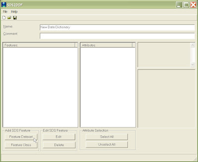
The above graphic shows the SDS2DDF as soon as it has been opened. Users can select to navigate through SDSFIE Feature Classes either by class, or grouped by Feature Dataset. The browser below shows the browse by Feature Dataset option. Users can also conduct a search by keyword to find a Feature Class that best meets there needs.


The user above has selected three Feature Classes. After selecting OK, the Feature Classes are loaded into the Main application screen (below).

Users can then browse through all of the loaded attributes for each Feature Class and determine which ones they would like to export to the final data dictionary. They can also view the description and domain values (if present) for each attribute field.
Users can also change certian properties for each feature, such as the alias name to be used (below).

Users can also change certain aspects on how the data is collected by the GPS receiver.


Once complete, the file is saved as an ASCII file (below).
To get the data into Trimble's Data Dictionary Editor, the user just selects 'Import ASCII file" from the 'File' menu.

The data can then be modified and saved as a DDF file for use in a Trimble GPS receiver.