After three beta testing periods, and a lot of new enhancements and optimizations, Shape2Earth Version 1.0 has been released for download at http://shape2earth.com/.
Shape2Earth uses freely available Geographic Information System (GIS) software to convert shapefiles into color coded Keyhole Markup Language (KML) files for visualization in Google Earth.
Shape2Earth provides a powerful tool for people and organizations who do not wish to invest thousands of dollars in professional GIS software in order to create powerful and compelling visual information. Shape2Earth can also quickly expand the capability of those who already have a significant investment in GIS for the lowest price possible.
Download Shape2Earth, and then look at the online blog to see what shape2earth can do for you.
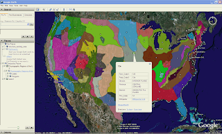
Physiographic Regions of the U.S.
this is very exciting
ReplyDeleteI want to develop our own GE application.
Is GE should be run when this application start?
Thanks