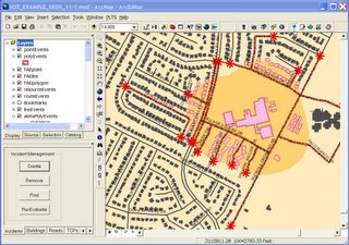
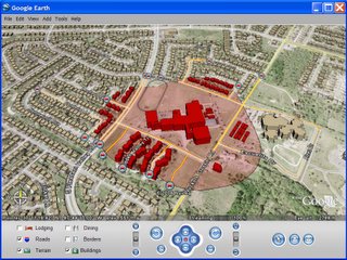
During an event (fire, accident, environmental, threat, attack, etc), those in charge need a picture of what is going on in order to make critical decisions. Examples of the kinds of information that they want to see is a cordon around the affected area, the ability to view impacted buildings and other assets, the location of traffic control points, and the location of their first responders (often using Automated Vehicle Location [AVL] technology).
I wanted to build a tool that would work with any ESRI ArcMap based tool. To do this, I built an XML based configuration wizard that is used to define what datasets listed in ArcMap’s table of contents are to be exported to KML on demand. The XML configuration file can also hold symbology information for each of the KML layers. While the ArcObjects extension can use the cartographic information from ArcMap to symbolize features, I have found that colors that work well in ArcMap do not always work as well in GE.
Whenever any data is modified (creation of a cordon, adjustments to a buildings status as people are evacuated), it can be instantly published to KML. The use of a configuration file allows a user to set it up for any ArcMap application. It simply exports all feature classes listed in the configuration file on demand. This allows any emergency response application based on ArcMap to use this tool.
My first test on the system used CH2M HILL’s iCIT emergency management application. As iCIT managed the application, the GE extension would publish the data for viewing in a command center in GE. The KML files were securely sent to the GE client machine using a secure Instant Messenger type of technology. Once the files were update on the client machine, a web service was used to reload the altered file in Google Earth.
 iCIT Emergency Management System
 GIS Data Dynamically Posted to Google Earth
Google Earth has proven to be an excellent, high level, visualization platform for people who need to make decisions. Most of my current testing has dealt with events that are limited in scope (view samples). I should be able to get my hands on a couple of other ArcMap based command and control application for testing. I would really love to see this type of capability used on a much larger scale to see how it might work.
I also have been working on the plumbing to be able to sit GE on top of a GIS package, and use it to create the datasets that have typically been generated by GIS software (buffers, unions, intersects, selection sets, etc.). I plan to look into using ArcEngine, ArcServer, and/or a combination of open source geospatial processing packages to create much of the functionality currently offered by GIS software using GE itself.
One item of recent interest from the Air Force is the use of the Commercial Joint Mapping Toolkit (C/JMTK) as the geoprocessing power behind GE.
I plan to follow up on this post with some work I have been involved with at the US Air Force Academy with automated vehicle location (AVL) and and unmanned aerial vehicles (UAVs) with streaming video into ArcMap and Google Earth.
Will you be making this export tool you developed free to the public?
ReplyDeleteSince I developed this ArcObjects tool for a client, I do not actually own the code. Otherwise, I would be happy to release it.
ReplyDeleteI was looking for code to convert KML to Shapefile which led me to your post. Did you mistype your comment here: "http://declanbutler.info/blog/?p=12". Did you mean to state your tool was a Shapefile to KML convertor rather than the other way around?
ReplyDeleteI'm part of a Forest Service team that produces thermal IR imagery of active wildfires and we see great potential for GE in terrain visualization with our imagery in overlays. If you're interested in emergency response to wildfire, we've got the largest collection of active wildfire thermal data and imagery available- FireImaging.com
ReplyDeleteIs this system available to emergency management and homeland security persons. I went the web sit and started to register but the closest contact I could relate to was the Coast Guard. Any ideas....
ReplyDelete